Centimeter-class positioning with "MICHIBIKI"
Centimeter-accurate location information with "MICHIBIKI" ?
The recent news that "MICHIBIKI, the Japanese version of GPS, enables centimeter-accurate location information to be acquired" has finally been realized! The topic is "MICHIBIKI", which is Japan's version of GPS.
What's that? I've seen that story in the news a few years ago. I'm sure some of you may be thinking, "I've seen that story in the news a few years ago...".
If you feel that the accuracy of your location information is not that good, even though your smartphone should be able to receive MICHIBIKI signals, why is that?
Completion Signal and Augmentation Signal
MICHIBIKI (QZSS is the official name) signals are divided into two main types.
These are the Completion Signal and the Augmentation Signal.
Many devices, such as smartphones, receive only MICHIBIKI's completion signals, which are equivalent to GPS signals.
Complementary signals alone do not provide centimeter-accurate position information.
Complementary signals increase the number of satellites.
As a quasi-zenith satellite system, MICHIBIKI has the advantage of staying near the zenith for a long time, which is observable even in areas surrounded by high-rise buildings, increasing the number of satellites that can be observed.
As a result, positional accuracy is indeed improved. Nevertheless, the accuracy is still limited to 10 meters to a few meters. With this method, known as "stand-alone positioning," it is difficult to achieve an accuracy of less than one meter, even with an antenna and receiver set that costs several million yen for surveying.
In addition, so-called car navigation systems display the car back on the road by synthesizing information from maps and other sensors.
MICHIBIKI's Augmentation Signal
The following is a list of augmentation signals transmitted by MICHIBIKI.
| Augmentation Signal | Approximate accuracy (horizontal) | Use of carrier phase | Time to first position |
|---|---|---|---|
| SLAS | 100cm | × | moment |
| Dual-frequency SBAS | 100cm | × | moment |
| CLAS | 6cm | ○ | Within 1 min |
| MADOCA-PPP | 10cm | ○ | 15 to 30 min. |
The following explanation focuses on the CLAS signal.
What is "CLAS" ?
CLAS (Centimeter Level Augmentation Service) is a method called PPP-RTK with the following two characteristics.
- Send correction values for error factors separately for common and grid portions.
- Use carrier phase.
It is only available in and around Japan (service range: from MICHIBIKI's official website [JAPANESE]), so it cannot be used in other regions. Also, since it uses the carrier phase, it cannot be measured with a smartphone's built-in receiver, etc.
Now is the time for CLAS
The environment for using CLAS is now in place, thanks to the expansion of the number of satellites to be augmented delivered by CLAS to a maximum of 17 from November 30, 2020, and the start of sales of equipment * capable of receiving such CLAS signals at low prices. We can say that 2022 is the year when we can receive MICHIBIKI and obtain centimeter-accurate location information.
* mosaic-CLAS (Septentrio), NEO-D9C (u-blox) as of May 2022
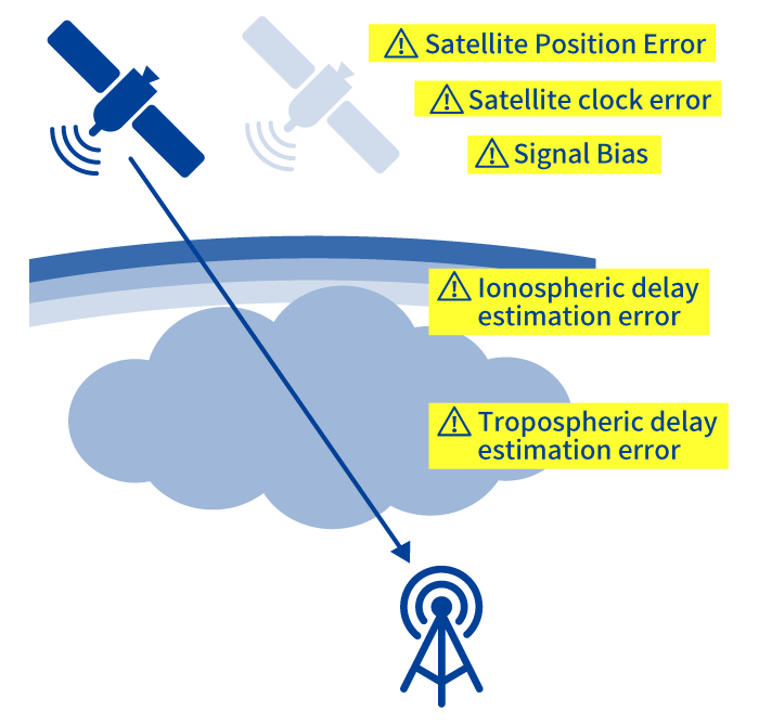
SSR (State Space Representation) and
OSR (Observation Space Representation)
- Satellite Position Error
- Satellite clock error
- Signal Bias
- Ionospheric delay estimation error
- Tropospheric delay estimation error
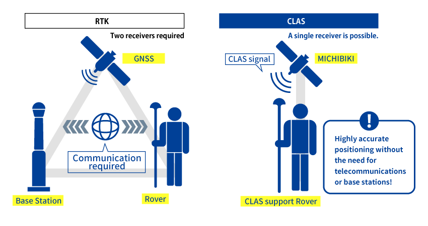
Comparison with RTK
RTK positioning has the advantage that the time required to determine the initial position is as short as a few seconds and the accuracy is about 2 cm.
However, RTK positioning is not possible without a reference point whose precise position is known, and without constantly receiving correction information from that reference point.
If severe accuracy is not required, CLAS will be sufficient for more applications.
In Closing
If you would like more detailed information or have any questions, we can hold a separate CLAS seminar.
Please contact us from our contact page.
Reference page: Prof. Nobuaki Kubo, Tokyo University of Marine Science and Technology,
"Current Status and Future of MICHIBIKI's Positioning Augmentation Signals" [PDF].
Our Products
iChidori® is an IoT-compatible centimeter-class location information service using GNSS (Global Navigation Satellite System) developed by our company. Please click here for a detailed introduction of the device. here